
Fichier:Map of the flooding areas of the Lake Nasser in the Wadi Halfa Salient.png

Taille de cet aperçu : 571 × 600 pixels. Autres résolutions : 228 × 240 pixels | 457 × 480 pixels | 909 × 955 pixels.
Fichier d’origine (909 × 955 pixels, taille du fichier : 1,25 Mio, type MIME : image/png)
Ce fichier et sa description proviennent de Wikimedia Commons.
| Description |
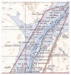
Deutsch: Überflutungsgebiet des Nasser-Stausees im Wadi Halfa Salient
English: Flooding areas of the Lake Nasser in the Wadi Halfa Salient |
||||||
| Date | see file history | ||||||
| Source |
own work, using the following files:
|
||||||
| Auteur | Maximilian Dörrbecker (Chumwa) | ||||||
| Autorisation (Réutilisation de ce fichier) |
Moi, en tant que détenteur des droits d’auteur sur cette œuvre, je la publie sous la licence suivante : Ce fichier est disponible selon les termes de la licence Creative Commons Attribution – Partage dans les Mêmes Conditions 2.5 Générique
|
||||||
| Autres versions |
|


Historique du fichier
Cliquer sur une date et heure pour voir le fichier tel qu'il était à ce moment-là.
| Date et heure | Vignette | Dimensions | Utilisateur | Commentaire | |
|---|---|---|---|---|---|
| actuel | 20 juin 2009 à 08:25 | | 909 × 955 (1,25 Mio) | Chumwa | {{Information |Description={{de|Überflutungsgebiet des Nasser-Stausees im Wadi Halfa Salient}} {{en|Flooding areas of the Lake Nasser in the Wadi Halfa Salient}} |Source=own work, using the following files: * [[:File:Wadi Halfa Salient-txu-oclc-6949452- |
Utilisation du fichier
La page suivante utilise ce fichier :
Usage global du fichier
Les autres wikis suivants utilisent ce fichier :
- Utilisation sur ar.wikipedia.org
- Utilisation sur bg.wikipedia.org
- Utilisation sur ca.wikipedia.org
- Utilisation sur de.wikipedia.org
- Utilisation sur el.wikipedia.org
- Utilisation sur en.wikipedia.org
- Utilisation sur id.wikipedia.org
- Utilisation sur it.wikipedia.org
- Utilisation sur ja.wikipedia.org
- Utilisation sur nl.wikipedia.org